
In an era defined by rapid urbanization, climate change, and evolving socioeconomic demands, the way we design and manage our cities must undergo a radical transformation. Traditional, static 2D planning methods are no longer sufficient to address the complex challenges of modern metropolitan areas. Today, city planners, developers, and local governments require dynamic, collaborative, and data-driven solutions to build resilient, sustainable communities. This is where arcgis urban comes into play.
Developed by Esri, the world leader in location intelligence, Esri ArcGIS Urban is a revolutionary, cloud-based platform that brings 3D city modeling and advanced spatial analysis to the forefront of the planning profession. By integrating geographic information systems (GIS) with intuitive design tools, this powerful urban planning software enables stakeholders to visualize, analyze, and optimize development plans in a highly collaborative digital environment.
In this comprehensive guide, we will explore the core features, applications, and strategic advantages of this platform, demonstrating how it is shaping the future of global urban development.
Table of Contents
Understanding ArcGIS Urban: The Evolution of 3D GIS
For decades, urban planning relied heavily on flat, two-dimensional maps and spreadsheets. While these tools provided essential spatial data, they often failed to convey the real-world impact of proposed developments on the existing skyline, sunlight access, and local infrastructure. The introduction of 3D GIS marked a paradigm shift, allowing planners to visualize geographic data in three dimensions.

This technology takes this evolution a step further. Instead of simply displaying static 3D buildings, it serves as an interactive, web-based platform designed specifically for the urban planning workflow. It acts as a digital canvas where planners can model zoning scenarios, track real estate development pipelines, and evaluate the performance of various design alternatives against real-world metrics.
By leveraging the principles of geodesign—a design framework that pairs environmental science with creative planning—the software ensures that every proposed change is backed by rigorous spatial data. Whether you are planning a single high-rise development or redesigning an entire metropolitan district, the platform provides the context needed to make informed, forward-thinking decisions.
Key Features of ArcGIS Urban
To understand why this platform is becoming the industry standard for modern municipalities, we must examine its robust feature set. The platform is built around three core pillars: visualization, scenario planning, and impact assessment.
1. Interactive 3D City Modeling
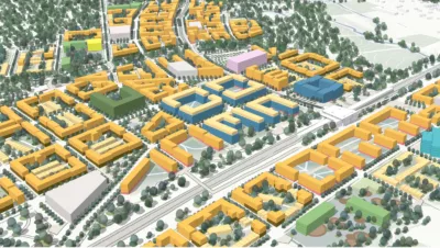
At the heart of the platform is its ability to generate a highly detailed, interactive digital twin of any urban area. By importing existing GIS data, aerial imagery, and 3D mesh layers, planners can create an accurate digital representation of their city. This model is not just a visual representation; it is a living database where every building, parcel, and street contains rich semantic information.
2. Scenario-Based Zoning and Land Use Planning
One of the most complex aspects of municipal administration is managing zoning regulations. Traditional zoning codes are often dense, text-based documents that are difficult for developers and the public to interpret.
If you want to know how to use ArcGIS Urban for zoning, the process is remarkably intuitive. Planners can input local zoning codes directly into the platform, which then automatically generates 3D zoning envelopes. These envelopes visually define the maximum allowable height, setbacks, and floor area ratios (FAR) for any given parcel. Planners can then run “what-if” scenarios, adjusting parameters like building heights or land-use designations to see how changes affect the surrounding neighborhood in real-time.
3. Real-Time Impact Metrics
As planners design different scenarios, the software automatically calculates key performance indicators (KPIs) and impact metrics. These metrics provide immediate feedback on how a proposed development will affect the community. Key indicators include:
- Population and Housing: Estimating the number of new residents, households, and affordable housing units generated.
- Employment: Calculating potential job creation based on commercial floor space.
- Environmental Impact: Modeling daily water consumption, wastewater production, solid waste generation, and greenhouse gas emissions.
- Transportation: Assessing parking demand and the impact on local traffic patterns.
4. Project Tracking and Development Pipeline Management
Keeping track of active, proposed, and completed development projects across a city can be a logistical nightmare. The platform solves this by offering a centralized dashboard for the city’s development pipeline. Planners can track the status of projects through various stages of approval, ensuring that all departments are aligned and that developers have a clear path to compliance.
Benefits of ArcGIS Urban for Local Government
Local governments face the daunting task of balancing economic growth with community well-being and environmental stewardship. Implementing Esri’s 3D planning solution offers numerous advantages for municipal agencies seeking to modernize their workflows.
Streamlined Development Review Processes
In many cities, the development review process is bogged down by manual checks, paper blueprints, and siloed communication. By utilizing this cloud-based platform, local governments can accelerate review timelines. Developers can submit 3D models of their proposed projects, which planners can instantly place into the digital twin to check for zoning compliance, view obstructions, and aesthetic integration. This reduces errors, minimizes back-and-forth communication, and saves both public and private resources.
Enhanced Public Engagement and Transparency
According to the American Planning Association, effective community engagement is fundamental to successful urban planning. However, traditional public town halls often suffer from low attendance and misunderstandings because residents struggle to interpret 2D blueprints.
This platform democratizes the planning process by allowing cities to share interactive, web-based 3D models of proposed developments directly with the public. Citizens can rotate the model, view before-and-after scenarios, and leave location-specific feedback online. This level of transparency builds trust, reduces community opposition (NIMBYism), and ensures that developments align with local desires.
Data-Driven Decision Making
With real-time access to spatial analytics and demographic data, municipal leaders no longer have to rely on intuition. Whether planning for transit-oriented development or assessing housing density, the platform provides the empirical evidence needed to justify policy decisions to city councils, investors, and the public. This alignment with the World Bank guidelines for sustainable urban development helps cities secure funding and drive equitable growth.
Improved Inter-Agency Collaboration
Urban planning does not happen in a vacuum. It requires coordination between transportation, public works, environmental protection, and economic development departments. The platform acts as a single source of truth, allowing different departments to collaborate on the same digital twin, ensuring that infrastructure investments are aligned with long-term land-use plans.
To learn more about the strategic advantage of these workflows, explore the benefits of ArcGIS Urban for local government to see how cities worldwide are modernizing their municipal operations.
Powering the Digital Twin and Smart City Planning
The concept of a “digital twin” has transitioned from science fiction to an essential tool for smart city planning. A digital twin is a virtual representation of a city’s physical assets, systems, and processes, updated with real-time data to optimize performance.
+-----------------------------------------------------------------+
|                       ArcGIS Urban Ecosystem                    |
+-----------------------------------------------------------------+
|  [Real-Time IoT Data] ---> [Digital Twin] <--- [3D GIS Data]    |
|                                 |                               |
|                                 v                               |
|                  [Spatial Analysis & Geodesign]                 |
|                                 |                               |
|        +------------------------+------------------------+      |
|        |                                                 |      |
|        v                                                 v      |
|  [Zoning Scenarios]                            [Public Engagement]|
+-----------------------------------------------------------------+
By serving as the spatial foundation of a city’s digital twin, the software integrates seamlessly with Internet of Things (IoT) sensors, traffic cameras, and environmental monitoring systems. For example, planners can overlay real-time air quality data or traffic congestion patterns onto their 3D city model. This allows for advanced spatial analysis to determine how new construction might affect microclimates, wind corridors, or urban heat islands.
Furthermore, this integration supports the United Nations Sustainable Development Goals, specifically Goal 11: Sustainable Cities and Communities. By simulating the environmental impacts of urban density, cities can design neighborhoods that minimize carbon footprints, maximize green spaces, and promote active transportation options like walking and cycling.
Practical Use Cases: ArcGIS Urban in Action
To understand the real-world impact of this technology, let us look at several practical use cases where the software is driving positive change.
1. Zoning Modernization
Many cities are operating under zoning codes written in the mid-20th century, which are ill-suited for modern, mixed-use, transit-oriented developments. Cities use the platform to visualize and rewrite their zoning codes. By modeling new, flexible zoning districts in 3D, planners can ensure that updated regulations encourage affordable housing development while preserving the unique character of historic neighborhoods.
2. Corridor and Transit-Oriented Development (TOD)
When planning new transit lines, cities must encourage high-density, mixed-use development around transit stations to maximize ridership. Planners use the platform to model different density scenarios around future transit hubs, analyzing how increased residential and commercial capacity will affect local infrastructure and transit demand.
3. Climate Resilience and Adaptation
Coastal cities facing sea-level rise use the software to model flood scenarios. By overlaying storm surge projections onto the 3D city model, planners can identify vulnerable infrastructure and design resilient zoning codes that restrict development in high-risk zones or mandate flood-mitigation designs for new constructions.
Getting Started: ArcGIS Urban Pricing and Features
If your organization is ready to transition to 3D smart planning, understanding the implementation process and licensing structure is the next step.
Understanding ArcGIS Urban Pricing and Features
Because Esri solutions are highly scalable, pricing is typically customized based on the size of the municipality or organization, the number of user licenses required, and integration needs. Generally, access to the platform requires:
- An ArcGIS Online Organizational Account: Since the platform is cloud-based, it operates within the secure ArcGIS Online ecosystem.
- User Type Licensing: Planners who need to create, edit, and manage scenarios require a compatible user type (such as Creator or GIS Professional) paired with an active license for the application.
- Viewer Access: Stakeholders, city council members, and the public can view published 3D models and scenarios for free, facilitating broad community engagement without additional licensing costs.
To get an accurate quote tailored to your organization, it is recommended to contact an Esri representative or certified distributor who can assess your specific spatial data infrastructure and municipal needs.
Implementation Best Practices
To ensure a successful rollout, organizations should follow these key steps:
- Consolidate Spatial Data: Ensure your city’s base GIS data—such as parcel boundaries, building footprints, and elevation models—is clean, accurate, and up to date.
- Start with a Pilot Project: Choose a specific neighborhood or upcoming corridor study to test the software’s capabilities and train your planning staff.
- Collaborate Across Departments: Involve IT, GIS specialists, and urban planners early in the process to ensure seamless data integration and workflow alignment.
Conclusion: Designing the Cities of Tomorrow
The challenges facing modern cities require a fundamental shift in how we approach urban design and municipal governance. Arcgis urban bridges the gap between complex geographic data and creative, visionary planning. By providing an interactive, web-based platform for 3D city modeling, scenario planning, and real-time impact analysis, it empowers local governments to make faster, more collaborative, and highly informed decisions.
Whether you are modernizing outdated zoning regulations, building a comprehensive digital twin, or seeking to increase public trust through transparent community engagement, this platform provides the tools needed to turn data into actionable, sustainable urban design. The future of urban planning is no longer flat—it is three-dimensional, collaborative, and driven by location intelligence. By embracing these advanced tools today, we can build the resilient, vibrant, and smart cities of tomorrow.